 Neolithic pottery - www.bbc.co.uk
 A volunteer army has joined ranks with the Museum of London Archaeology. They will record items washed up in thousands of sites around the UK for items uncovered by floods. The recruits will be trained to record information and use a web-based system to co-ordinate information on finds. See the full Guardian story here.
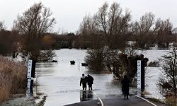
Dog walkers, bird watchers, amateur historians and geology enthusiasts will help record sites that have been uncovered by storms and flood tides during the worst flooding the UK has seen since 1947—some say 100 years.
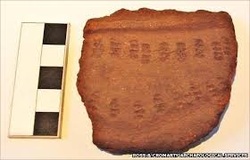
Every storm and flood tide during this horrific winter, particularly for those living in the north of England, has washed archaeology out of thousands of sites around the British coastline. Medieval bones and Stone Age cooking pots have tumbled out of disintegrating cliffs, unknown Anglo-Saxon jetties sit proud of the water on the river Thames, and previously unknown shipwrecks have been revealed around the coast.
Dog walkers, bird watchers, amateur historians and geology enthusiasts will help record sites that have been uncovered by storms and flood tides during the worst flooding the UK has seen since 1947—some say 100 years.
Every storm and flood tide during this horrific winter, particularly for those living in the north of England, has washed archaeology out of thousands of sites around the British coastline. Medieval bones and Stone Age cooking pots have tumbled out of disintegrating cliffs, unknown Anglo-Saxon jetties sit proud of the water on the river Thames, and previously unknown shipwrecks have been revealed around the coast.
 www.theguardian.com
 Roman forts and villas, prehistoric forests, and medieval port structures are suffering from rising sea levels.
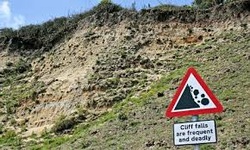
Sites at risk from battering by waves and wind include traces of a port used centuries before the Romans took it over, the fragile traces of Iron Age salt-working sites, the Roman port of Fishbourne, and shipwrecks in Cornwall.
Many areas can only be recorded, not preserved. An example is Dunwich in Suffolk, where only a few cottages, a pub, and a little museum now mark a once thriving walled town and port.
 www.theguardian.com
 At the Tower of London, flooding tides are eroding the remains of structures older than the tower itself in the bank just above London Bridge. Further downstream, tides are damaging massive medieval jetty timbers at Greenwich.
Reports from the public will be entered on a database which will gradually build, linking with older documentation and work by local history societies, to record thousands of sites. However, professional archaeologists will intervene where there is a critical threat to a site of national importance.
On the bad side, flooding is rated as worst environmental climate change threat facing the UK. My sympathy goes to all the people whose homes have been flooded for nearly a month. That must be a horrible position to be in.
As a compensating factor, ordinary walkers can contribute to a data base to record more of England's history.


 RSS Feed

